- Home
- China Guide
- Taiwan
- Attractions
- Taroko National Park
Taroko National Park
Founded in November 1986, Taroko National Park covers Hualien, Nantou and Taichung. It's well-known for its great, nearly vertical marble canyon views. It is particularly important to note that due to the 2024 earthquake and typhoons, there were lots of rockfalls and landslides in the park. Its geological structure isn't stable yet, and workers are still fixing and rebuilding roads and trails. So Taroko National Park isn't fully open—it might take as long as 10 years to open all of it.
- Chinese Name:太鲁阁国家公园 Tà Lǔ Gé Guó Jiā Gōng Yuán
- Duration: 1-3 hours
- Entrance Fee: Free
-
Opening Hours: Visitor Center 8:00-17:00
Trail Opening Scope: Since January 2025, partial sections of 3 trails have been open, including Bilu-Yangtou Cross Trail, Pingfeng Mountain Trail, and Qilai North Peak & Qilai East Ridge Trail. However, most trails remain closed. Roads around Yanzikou and Changchun Shrine are also blocked, while the Qingshui Cliff viewing platform is temporarily closed with no parking available.
Time-Limited Access for Partial Roads: Self-driving cars can use the canyon road to Hehuan Mountain, but they can only enter at 8:00, 12:00 and 16:00 every day. You must leave the park by 17:30, and most of the road is dirt or has potholes.
For more detailed open information, it is recommended to check the official website
- Best time to visit:September to October
- Address: No. 291, Fushi, Xiulin Township, Hualien County, Taiwan Province, China
- How to get there: Taiwan Railway (Hualien Station/Xincheng Station); Hualien Bus (Routes 126, 1129, 1133, 1141)
Highlights of Taroko National Park
Taroko Gorge
Taroko Gorge is the core landscape of Taroko National Park. It’s a U-shaped marble gorge—formed after the Eurasian Plate hit the Philippine Sea Plate 4 million years ago, then carved by the Liwu River for millions of years. It stretches 20 kilometers from Taroko to Tianxiang, called "Luge Youxia" (the Serene Gorge of Luge) and is one of Taiwan’s Eight Great Scenic Spots. The two sides of the canyon go straight up high. Water erosion makes the marble layers show white, gray and black stripes in turn, and places like Changchun Shrine and Jiudong Cave are along the way. When you walk here, you can look closely at rock folds and joints, and feel the great beauty of "gathering heaven and earth’s charm" for yourself. It’s great for both geology fans to enjoy and hikers to get close to nature.
Opening information: Not open yet.
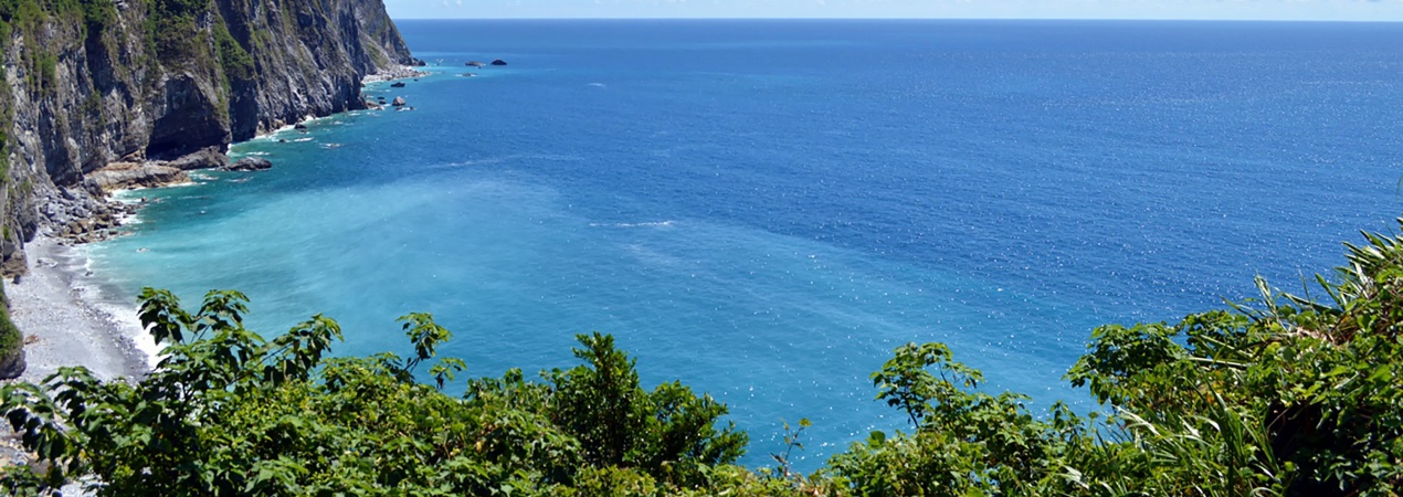
Qingshui Cliff
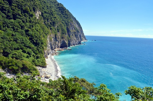 Qingshui Cliff
Qingshui Cliff is one of the most visually striking landscapes in Taroko. Stretching 21 km along the Heping-Chongde section of the Suhua Highway, it rises almost vertically (nearly 90 degrees) from the sea level to Qingshui Mountain (2,408 meters), making it a world-class coastal cliff landform. The gneiss and marble forming the cliff are hard in texture; they have stood firm despite millions of years of wave erosion. The white rock faces contrast sharply with the deep blue Pacific Ocean. Driving on the coastal road beside the cliff feels like being above the sea—with steep cliffs on one side and the vast ocean on the other, offering a dual experience of thrill and serene grandeur. It is also a paradise for photographers. At sunrise, sunlight falls on the cliff faces, and the rock textures blend with the sea glow, creating countless classic shots.
Opening information: Not open yet.
Swallow Grotto & Jiudong Cave
Connected to each other, Swallow Grotto and Jiudong Cave are the highlight section along the Central Cross-Island Highway, perfectly showing the combination of human engineering wisdom ("man conquers nature") and natural wonders. Swallow Grotto gets its name from the swiftlets that once nested in the eroded caves on the marble cliffs. Though the swiftlets have moved away, the potholes covering the rock walls still clearly record traces of water erosion, making it a vivid geological teaching site. Not far ahead lies Jiudong Cave. This 800-meter trail was once part of the old Central Cross-Island Highway, chiseled by hand with axes and hammers. Its winding corridors (with nine turns and eighteen bends) are embedded in the mountain. After heavy rain, countless "temporary waterfalls" gush down the rock walls; water droplets fall from the cave ceiling, mixing with the sound of streams to form a natural melody. A 40-minute walk here lets you fully experience the unique scenery of "cliffs at every step, caves everywhere".
Opening information: Swallow Grotto is closed. Only a partial section of Jiudong Cave is open for walking.
Changchun Shrine
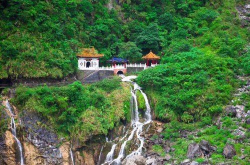 Changchun Shrine
Changchun Shrine is a Taroko landmark that mixes natural beauty and human warmth. It’s built just to remember 225 workers who died building the Central Cross-Island Highway. An earthquake destroyed its original structure, and later it was rebuilt as a cave-like building. The spiritual tablets inside quietly tell how hard the road builders worked. A 380-step "Heavenly Ladder" winds up behind the shrine. If you reach the top, you’ll get to Guanyin Cave. The full map of the cross-island highway’s construction is kept there—it clearly shows the great thing workers did: "overcoming dangers with their effort" back then. Also, it’s the first spot when you enter the gorge. Its Tang-style buildings sit against the cliff, tucked in the green mountain wall. With "Changchun Waterfall" (which splits into streams in front of the shrine), it makes a natural landscape painting.
Opening information:Still open.
Educational Value
Taroko Gorge is known as a "natural laboratory" for plate movement and water erosion. The collision between the Eurasian Plate and the Philippine Sea Plate 4 million years ago formed the marble rock base here, while the Liwu River’s erosion over millions of years shaped the U-shaped canyon landform. This complete process of "plate compression for mountain-building + stream headward erosion" allows visitors to directly understand how internal forces (crustal movement) and external forces (water action) work together to shape the Earth’s surface.
Activities to do at Taroko National Park
Taiwan Folk Experience: The Bulowan Plateau, where the Bulowan Rest Area is located, is the core cultural experience area of the Taroko people. Currently, its basic rest and cultural services are available as usual. The Atayal Exhibition Hall on the lower plateau is open for visits. Visitors can purchase handcrafts like woven items, and on holidays, Atayal women also demonstrate traditional weaving techniques on site.
Drop us a line and we'll connect you with the top China expert in no time!
 Sun Moon Lake
 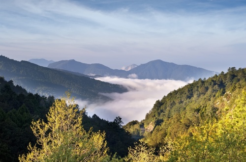 Alishan
 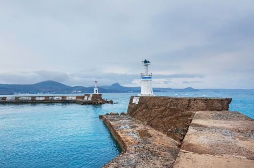 Kenting National Park
  Pudacuo National Park