- Home
- China Guide
- Xinjiang
- Attractions
- Ulungur Lake
Ulungur Lake
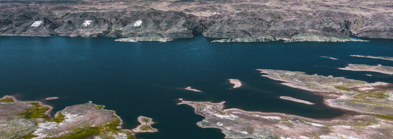
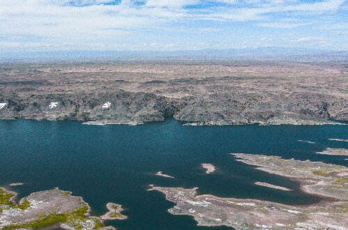
Ulungur Lake is located in the north of Xinjiang. With a water area of 1,035 square kilometers, it is one of the top ten inland freshwater lakes in China. It has the only waterfront Yardang landform in China. At the same time, it is also an important node of the world's third migratory bird channel, with 23 famous fish species and more than 300 bird species.
- Chinese name: 乌伦古湖 Wū Lún Gǔ Hú
- Suggested time: 2 - 3 hours
- Ticket: The Ulungur Lake National Wetland Park is free of charge, while the ticket for the Golden Beach Scenic Area is 38 yuan per person.
- Open hours: Open from 09:00 to 20:30. No entry after 19:00.
- The best time to visit: For bird-watching, the periods from mid-March to late May and from early September to mid-November are ideal. For experiencing winter fishing, the winter months are perfect. Generally, all year around has its own charm.
- Address: Located in Fuhai County, Altay Region, Xinjiang Uygur Autonomous Region. The Golden Beach Scenic Area is at the 15 - kilometer mark of Huanhu Road, Fuhai County.
- How to get there: It is recommended to take a taxi or go on a self-driving tour to reach the scenic area.
Highlights of Ulungur Lake
Ulungu Lake (Golden Beach Scenic Area)
 Ulungu Lake
Ulungu Lake (Golden Beach Scenic Area) is a concentrated tourist destination with both marine characteristics and landform diversity. The Golden Beach Scenic Area is an important part of the Ulungu Lake Scenic Area. The water area of Ulungu Lake is 1,035 square kilometers, consisting of Buluntohai (Dahaizi) and Jili Lake (Xiaohaizi). The Golden Beach Scenic Area is located on the east coast of Buluntohai in Ulungu Lake.
Ulungur Lake is also a "mirror of the sky" that makes people feel calm. Every year when the ice and snow on Ulungur Lake melts, the waters around the lake are wide and calm. When clouds float in the sky, their reflections appear in the lake, like a "mirror of the sky", attracting many photographers to come and create.
Maritime Devil City
 Maritime Devil City
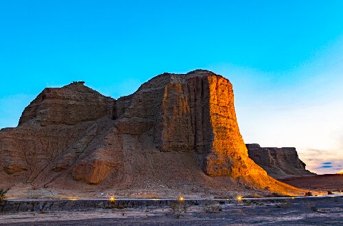
The Yardang landform of the Maritime Devil City, stretching for more than approximately 5 kilometers, is a rare spectacle in Xinjiang. The slopes are dome-shaped, with an average vertical height of 20 meters. The Yardang landform here, composed of Cretaceous sandshale formed over 100 million years ago, displays vibrant colors due to differences in rock layer materials. Shaped by long-term wind erosion and rainfall, it has been carved into countless strange forms, resembling skyscrapers, palaces, pagodas, and more.
Located at the estuary of Ulungur Lake on the eastern shore of Jili Lake, the Maritime Devil City combines the grandeur of a vast sea with the beauty of a serene lake. Travelers have hailed it as a "geological wonder of Yardang" and a "living Devil City."
Educational Value
Ulungur Lake developed on the basement of Paleozoic folds. It was eroded during the Mesozoic period, leading to the absence of sedimentary rock formations. The Tertiary rock system is relatively well-developed. Based on the distribution of sediments around the lake, lake terraces, lake erosion cliffs, and buried lacustrine sediments, the lake took shape in the Middle Pleistocene, with its basic pattern established in the Late Pleistocene. Observing Ulungur Lake helps understand the impact of crustal movement and glaciation (in paleogeological periods) on lake formation.
Activities to do at Ulungur Lake
Geological and Geomorphological Research: Through field observations and wind erosion simulations at the Maritime Devil City, uncover how Yardang landforms are shaped by wind-water erosion and crustal movements.
Water Sports: Experience exciting water activities like surfing and enjoy holidays in the cool lake waters.
Drop us a line and we'll connect you with the top China expert in no time!