- Home
- China Guide
- Xinjiang
- Attractions
- Pamir Scenic Area
Pamir Scenic Area

The Pamir Scenic Area is rich in unique tourism resources. It features the world-famous Stone City Ruins, the fascinating Alar Golden Grassland National Wetland Park, distinctive Tajik folk customs, the time-honored Silk Road culture, and precious and rare plateau organisms. The planned total area of the Pamir Scenic Area is 3.1 square kilometers. In 2014, it was awarded the title of China's first "International Plateau Customs Tourism Destination".
- Chinese name: 帕米尔旅游景区 Pà Mǐ ěr Lǚ Yóu Jǐng Qū
- Suggested time: One day
- Ticket: 40 yuan per person
- Open hours: Generally, most attractions are open from 8:30 - 21:00. However, attractions like Karakul Lake may have different opening hours due to seasonal and weather conditions. It's better to check in advance.
- The best time to visit: From June to September
- Address: Taxkorgan Tajik Autonomous County, Kashgar Prefecture, Xinjiang Uygur Autonomous Region, China
- How to get there: It is recommended to travel by self-driving, which will be more convenient.
Highlights of Pamir Scenic Area
Stone City Ruins
The Stone City Ruins Scenic Area, the core attraction of the Pamir Tourist Area, dates back to the Tang Dynasty and was a strategically important castle on the ancient Silk Road. Covering over 100,000 square meters, it is divided into the inner city (relatively intact) and the outer city (severely damaged), with a perimeter of about 1,285 meters. Composed of city walls, gates, temples, residential ruins, and a Qing Dynasty castle, it vaguely retains the majesty of an ancient castle. More than a thousand years ago, the Tajik ancestors completed this huge project without advanced tools, making it one of the three most famous stone cities in Chinese history.
Caiyun Renjia Folk Village
Folk Village is located to the east of the Tourist Service Center and Tourism Avenue. To preserve the time-honored Tajik folk culture, the village showcases a variety of intangible cultural heritage, including Tajik wedding customs, traditional folk songs, eagle dances and costumes, as well as various traditional handicrafts.
Alar Golden Grassland
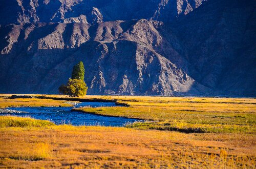 Alar Golden Grassland
The Alar Golden Grassland scenic spot is Alar National Wetland Park. As a swampy meadow, the Alar Wetland sits at an altitude of 3,100 meters, covering a total area of about 100,000 mu. In summer, it presents a green meadow; in autumn, the wetland vegetation turns golden, glowing under the sun, hence the name "Golden Grassland"; in winter, Alar becomes a snowfield "wrapped in silver", offering even more stunning scenery.
White Sand Lake
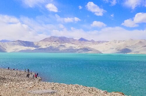 White Sand Lake
White Sand Lake is high-altitude flat lake formed by glacial meltwater from Muztagh Ata flowing through Bulunkou. At an altitude of about 3,300 meters, it covers an area of 44 square kilometers and gets its name from the white sand on the mountains beside the lake. Under sunlight, the lake surface changes unpredictably throughout the day. The lakeside is lined with sand dunes covered in silvery-white fine sand, and the reflections of snow-capped mountains and sand dunes in the water create a unique landscape of lakes and mountains.
Karakul Lake
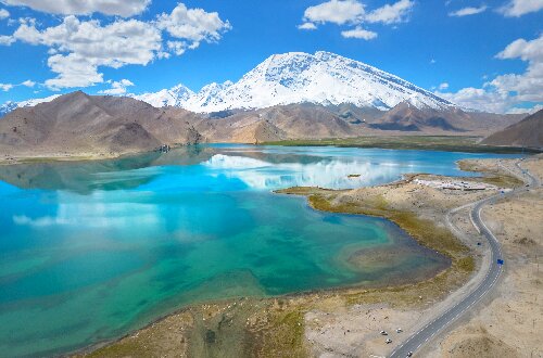 Karakul Lake
At an altitude of 3,560 meters and covering a total area of about 10 square kilometers, it is the highest lake in Xinjiang. The lake is renowned for its deep, dark waters, with a depth of more than 30 meters, hence the name "Karakul". In the Kirgiz language, "kara" means "black" and "kul" means "lake", together translating to "Black Lake". However, as its water changes color with the seasons and time, it is also known as the "Color-Changing Lake". It is a high-mountain glacial erosion and moraine lake. The water surface mirrors the majestic and mysterious Muztagh Ata, creating a captivating landscape.
Panlong(Coiling Dragon) Ancient Road
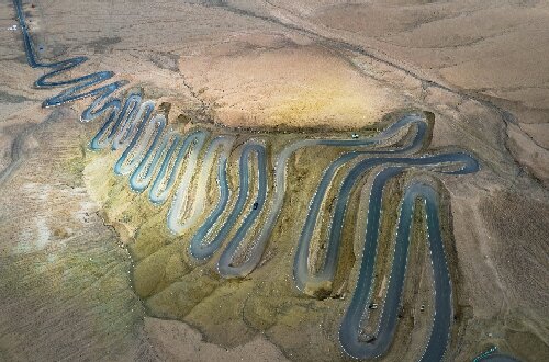 Panlong(Coiling Dragon) Ancient Road
The most winding road on the Pamir Plateau, with more than 600 extreme bends, is known as the "Sky Road Wonder" of the Pamir Plateau. The road is 75 kilometers long, climbing from an altitude of 3,000 meters to 4,200 meters, with a maximum ascent of nearly 1,000 meters. It has more than 600 S-shaped and U-shaped bends, some of which reach 180 degrees or even 270 degrees. When standing on the mountaintop and overlooking the entire road, you will have the visual of "the backbone of a giant dragon".
Educational Value
Located on the Pamir Plateau, the Pamir Tourist Area features diverse landforms including snow-capped mountains, glaciers, river valleys, and wetlands. Visitors can directly observe the morphology of plateau river valleys, understand their formation processes and characteristics, and learn about geological processes such as fluvial erosion and deposition.
Activities to do at Pamir Scenic Area
Watercolor Sketching Creation: Conduct watercolor painting courses using the plateau's mountains, rivers, lakes, and grasslands as creative themes.
Photography Research: Leverage the scenic area's unique natural and cultural landscapes to carry out photography workshops, learning landscape and humanistic photography techniques, and capturing the plateau's beautiful moments and distinctive customs through lenses.
Landform Observation: Visit Muztagh Ata and hike to observe glacial landforms up close, exploring glacier formation, movement, and geological impacts.
Drop us a line and we'll connect you with the top China expert in no time!