- Home
- China Guide
- Xinjiang
- Attractions
- Keketuohai
Keketuohai
Keketuohai, which means "blue river bay" in Mongolian and "green jungle" in Kazakh, refers to a large scenic area near Keketuohai Town. It consists of four parts: the Irtysh Grand Canyon, Kekesuli, Iremut Lake, and the Karashenger Earthquake Fault Zone. The Irtysh Grand Canyon is the main scenic spot of Keketuohai. As a natural landscape, it combines gorgeous canyon rivers, mountain forests, mineral resources, lakes, and unique earthquake fault zones, integrating geological culture, regional characteristics, and ethnic customs.
- Chinese name: 可可托海景区 Kě Kě Tuō Hǎi Jǐng Qū
- Suggested time: 1-2 days
- Ticket: The ticket price is 116 yuan including round-trip shuttle bus. Additional fees apply to different scenic spots within the scenic area, and the prices vary. Charges also differ for different groups.
- Open hours: Generally from 8:00 to 20:00 (18:30 is the last admission time). The opening hours of the scenic area are subject to changes due to weather conditions. Please refer to the daily opening information announced by the scenic area for the actual schedule.
- The best time to visit: From June to October
- Address: Keketuohai Town, Fuyun County, Altay Region, Xinjiang Uygur Autonomous Region, China
- How to get there: Self-driving is a convenient way to reach the scenic area.
Highlights of Keketuohai
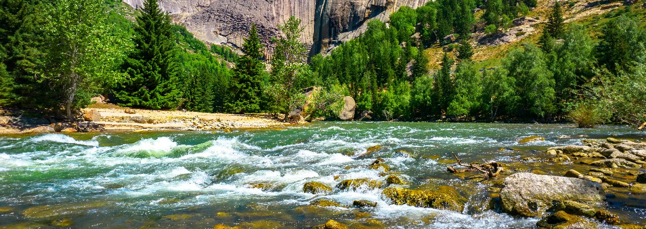
Irtysh Grand Canyon
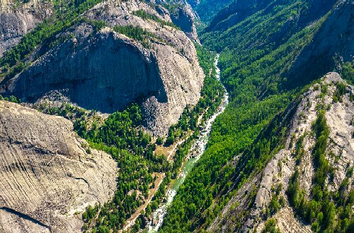 Irtysh Grand Canyon
The Irtysh Grand Canyon is located in the northeast of Keketuohai Scenic Area, covering an area of 463.36 square kilometers. It was formed by the long-term erosion, cutting, and transportation of surface rocks by the Irtysh River, which gradually created a canyon landform hundreds of meters deep. Formed during the Yanshanian period (208 million to 65 million years ago), the canyon features a typical granite landform. Due to the cold climate, the granite has continuously split, eventually formed various steep mountains with smooth surfaces and unique shapes, such as Camel Mountain, Elephant Mountain and Bell Mountain. Apart from various granite formations and peaks, other attractions include Longmen Square, No.3 Ore Vein, Birch Forest, Shuimogou, and Wild Grape Ridge.
The Irtysh River, the largest tributary of the Ob River and known as the "Silver Water", is the only river in China that flows into the Arctic Ocean. The scenery along both banks of the river is beautiful and magnificent. The upper reaches of the Irtysh River are mainly replenished by snowmelt, ice melt, and precipitation, while the lower reaches mainly are from snowmelt and precipitation. The Irtysh River Valley is broad with mighty water potential, and its water volume is second only to the Ili River, ranking second in Xinjiang, China.
No.3 Ore Vein
The No.3 Ore Vein is not only one of the largest and most typical rare-metal-bearing granite veins known in the world, but also a well-deserved "geological and mineral museum". Rare and radioactive elements such as lithium, beryllium, tantalum, niobium, rubidium, cesium, cobalt, chromium, and uranium are all found in the No.3 Ore Vein.
Shenzhong Mountain
Also known as Amir Sara Peak, Shenzhong Mountain is located about 40 kilometers upstream of the Irtysh River. Like a giant bell, this granite peak stands tall in the Irtysh River Valley. Birch trees, pine trees, and Siberian spruces grow in the crevices of the rock face. After rain, when the sky clears, white clouds curl around the peak and rainbows arc across the sky, creating a spectacular scene.
Kekesuli
Kekesuli, at an altitude of 1,333 meters, is also known as Wild Duck Lake. The lake covers an area of approximately 1.78 square kilometers with an average water depth of about 2 meters. Formed by water accumulation in a lake basin created by multi-stage fault subsidence, it is a natural marsh wetland. The lake features more than 20 floating islands of various sizes and is rich in aquatic plants. In summer and autumn, large flocks of animals such as whooper swans, demoiselle cranes, seagulls and wild ducks inhabit here.
Karashenger Earthquake Fault Zone
The Karashenger Earthquake Fault Zone caused by the 1931 Fuyun magnitude 8 earthquake is one of the rare earthquake fault zones in the world. The earthquake left a spectacular collapse area 1,500 meters long and 350 meters wide in the center of Karashenger, with a 63-meter landslide fracture surface formed in the collapse area. Due to minimal impact from natural damage and human factors, the relics have been completely preserved to this day. It is a spectacular, amazing, and well-preserved earthquake relic in the history of world seismology, known as the "Earthquake Museum," and possesses important values for geological research, scientific investigation, eco-tourism, etc.
Iremut Lake
Located in the north of Fuyun County, Iremut Lake is formed by the confluence and water storage of the Irtysh River and the Kayirt River. It is the largest fault basin on the Fuyun Earthquake Fault Zone, presenting a huge "8" shape when viewed from the air. In Kazakh, "Iremut" means "eddy". The lake stretches about 7.5 kilometers from north to south and about 4.5 kilometers from east to west, with a water storage capacity of 113 million cubic meters.
Educational Value
The Kalaxiang'ge earthquake fault zone stretches 176 kilometers in length, with a general width of 10 meters and a maximum width of 4 kilometers in the epicentral area. Meanwhile, it serves as a "mecca" for geological research, holding irreplaceable scientific significance for studying seismic faults, regional tectonic environments, stress fields, dynamic sources, and topographical, geomorphological, vegetative, and hydrological changes caused by earthquakes.
Activities to do at Keketuohai
Explore the No.3 Ore Vein: Enter the No.3 Ore Vein to observe outcrops of rare metal ores such as lithium, beryllium, and tantalum. Through comparisons of geological specimens, learn about the formation principles of granite pegmatite veins.
Hiking: In summer or autumn, Keketuohai boasts pleasant scenery, perfect for hiking. You can trek along the Irtysh River and admire the natural landscapes on both banks.
Skiing: The Keketuohai International Ski Resort has a snow season lasting more than 7 months, with deep snow and gentle ski slopes. It features "numerous ski runs, light wind, comfortable body sensation, and comprehensive facilities", making it suitable for skiing enthusiasts of different skill levels.
Drop us a line and we'll connect you with the top China expert in no time!