- Home
- China Guide
- Xinjiang
- Attractions
- Kanas Lake
Kanas Lake
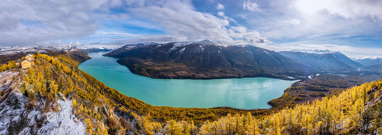
Kanas Lake is located in the northern part of Burqin County, Altay Prefecture, Xinjiang, nestled in the deep forests of the Altai Mountains. With an elevation of 1,374 meters and a maximum depth of 188.5 meters, it is the deepest glacial moraine dam lake in China.
- Chinese name: 喀纳斯湖 Kā Nà Sī Hú
- Suggested time: 1 - 2 days
- Ticket: In the peak season (from May 1st to October 15th), the one - entry ticket for Kanas Scenic Area is 230 yuan per person (including 160 yuan for the entrance ticket and 70 yuan for the vehicle ticket).
- Open hours: From May 1st to October 15th (summer operation mode), it is open from 8:00 to 20:00. From October 16th to April 30th of the next year (winter operation mode), it is open from 10:00 to 18:00.
- The best time to visit: All year around. But the most popular time is from late August to early October, when the forest turns colorful, showing a beautiful autumn scenery. From June to August is also a good time for summer vacation, with pleasant temperature.
- Address: Located in the northern part of Burqin County, Altay Region, Xinjiang, China. It is in the middle section of the Altai Mountains.
- How to get there: It is recommended to take a taxi or go on a self-driving tour to reach the scenic area.
Highlights of Kanas Lake
Kanas Lake
 Kanas Lake
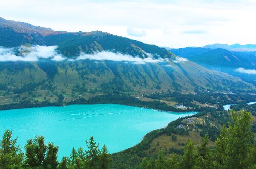
Formed approximately 200,000 years ago, Kanas Lake is one of China's deepest glacial moraine dam lakes. Nestled in the dense forests of the Altai Mountains, this alpine inland freshwater lake is hailed as a "fairyland on earth" and a "divine garden". Fed by glacial meltwater from mountains like Kuitun and Friendship Peak, as well as local precipitation, the lake sits at an elevation of 1,374 meters, covering an area of 45.73 square kilometers. With its deepest point at 1,181.5 meters above sea level (188.5 meters in depth), it holds a water storage capacity of 5.38 billion cubic meters.
Shaped like a crescent moon, the lake area features prominent landscapes such as Camel Neck Bay, the Color-Changing Lake, and Wolong Bay (Crouching Dragon Bay). In 2009, China National Geography magazine named Kanas Lake "the Most Beautiful Lake in China".
Fairy Bay
At an altitude of 1,327 meters, Fairy Bay becomes the widest section of the Kanas River due to the barrier formed by downstream debris flows and mountain collapse deposits. With slow-flowing water, it is always shrouded in mist like a gossamer veil, whether in summer or winter, in the morning or after rain. When sunlight shines on the water, it sparkles like pearls sprinkled across the surface, hence it is also known as the "Pearl Shoal".
Moon Bay
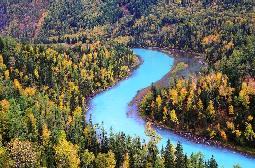 Moon Bay
At an altitude of 1,326 meters, the Kanas River forms a river bend here with extremely curvy, resembling a crescent moon—hence the name "Moon Bay". Its formation is related to the lateral erosion of the river. Due to the water's movement patterns at the river bend, the river eroded laterally toward its west bank during its evolution, eventually shaping the channel into the beautiful crescent shape seen today.
Several palm-shaped grass shoals on the water are known as the "Footprints of the Gods". This is a paradise for photographers: from spring to autumn, and from dawn to dusk, under different climatic conditions and lighting, Moon Bay presents varied scenery, offering endless wonderful frames for photography enthusiasts.
Wolong Bay (Crouching Dragon Bay)
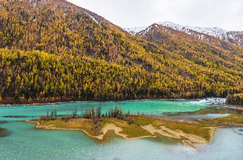 Wolong Bay (Crouching Dragon Bay)
At an altitude of 1,325 meters, Wolong Bay gets its name from a river islet resembling a dragon in the middle of the river bend. The Kanas River here flows through glacial deposits at the bottom of a U-shaped valley formed by ancient glaciers. Originally an ordinary river bend, it transformed due to a debris flow that erupted in a left-bank tributary gully upstream from Wolong Bay several years ago, coupled with multiple collapses on the right bank. The debris flow and collapse deposits silted up and narrowed the local river channel, causing the upstream river surface to widen and water flow to slow down. Sediments accumulated in the river and along the banks, forming the river islet and creating the splendid scenery of Wolong Bay.
Fish-Watching Platform
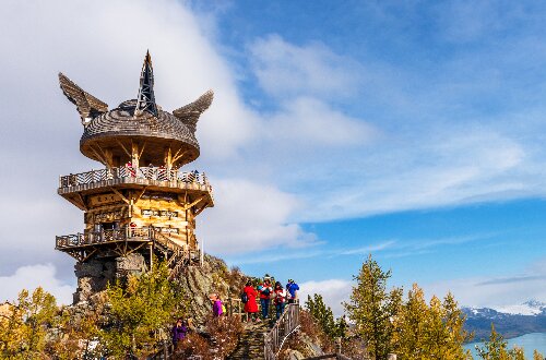 Fish-Watching Platform
The Fish-Watching Platform is 19 meters high and weighs 777 tons. The vertical drop from the lake surface is more than 660 meters. It is in the best position to observe the "lake monster" (Kanas Lake is famous for the legend of the lake monster). The Fish-Watching Platform consists of two platforms and one pavilion, which can accommodate more than 100 people to view the scenery at the same time. The top is semi-spherical with four symmetrical and strange shapes similar to wings, which symbolize the tail of the lake monster and the wings of the eagle. The Fish-Watching Platform is the only optimal platform to stop and enjoy the beautiful scenery of Kanas. Climbing up the Fish-Watching Platform, you can see the lake and mountains at a glance, which is refreshing.
Yaze Lake
Yaze Lake is an oxbow lake formed after the Kanas River changed its course. With a broad lake surface and clear water, it is surrounded by vast swamps and grasslands. This area serves as a habitat for numerous waterbirds, where wild ducks, swans and other waterfowl are often seen frolicking and foraging in the lake.
Educational Value
Kanas Lake is a typical glacial dam lake formed by Quaternary glacial movements. Glacial landform features such as U-shaped valleys, cirques, and horn peaks on both sides of the lake basin are clearly visible. For example, Harakat Mountain where the Fish-Watching Platform is located is a horn peak formed by glacial erosion. By observing these landforms, one can intuitively understand the process of glacial movements shaping the earth's surface, as well as the relationship between climatic changes and glacial advances/retreats in geological time.
Activities to do at Kanas Lake
Winter Skiing: If visiting in winter, you can experience snow sports like skiing.
Starry Sky Photography: With fresh air, the Kanas area is an ideal spot for stargazing and capturing starry skies.
Drop us a line and we'll connect you with the top China expert in no time!